Measuring tree canopy cover either in wide areas or on specific parcels. If trees are widely spaced, estimates of tree density can also be determined. Changes in tree canopy cover due to tree mortality or removal can be determined by evaluating images made in different years.
- Aerial imagery of the area to be assessed. Imagery may be in black and white or color, including false color images produced from multispectral or hyperspectral digital images. Ideally, photographs should be taken during early to mid summer, when deciduous trees are in full leaf. Also, photos taken near midday have less shadowing and may be easier to interpret. Resolution of at least 0.5 to 1 m (about 1.5 to 3 ft) is generally desirable. The plane of photography should be parallel to the ground surface; orthocorrected images are best.
Coupled with other aerial photo interpretation techniques, photogrammetry can also be used to map the distribution of some tree species or forest types. It can also be used to monitor tree removal and mortality. However, aerial photos generally cannot provide detailed data on individual trees. Ground survey techniques are preferred or should be used in conjunction with photointerpretation when detailed condition or species data about individual trees is necessary.
Photointerpretation is also subject to classification errors, i.e., misinterpretation of the image. For example, tree shadows can be erroneously included as tree canopy or shrubs may be mistakenly classified as trees. Classification errors can lead to consistent overestimates or underestimates of canopy cover. Classification errors associated with image characteristics may be minimized by using the following types of images:
- color or false-color images that provide clear distinctions between canopy
and shadow
- high-resolution images under magnification
- stereoscopic image pairs
A person skilled in photointerpretation is also less likely to make classification errors than a neophyte photointerpreter. Some field checking of photogrammetric results is advisable, especially when training new personnel or when imagery is suboptimal.
Certain photogrammetric methods (e.g., digital image analysis of multispectral imagery) are well suited to large areas, whereas others (e.g., dot grid estimates from large scale aerial photos) are better suited to smaller areas. If it is impractical to measure the entire area of interest, the area may be sampled using stratified random sampling. Once sampling strata are assigned, the actual plot or area to be estimated should be chosen randomly. An easy way to do this is to establish a coordinate system based on the length and width of the area to be sampled. A random number table or random number generator can then be used to pick the starting location of each plot. For example, on a large aerial photo 55 cm wide and 81 cm long, the random number pair 35 and 68 would place a sample point 35 cm from the left edge and 68 cm from the bottom.
If canopy assessments are made on sample plots rather than the entire area of interest, the same plots should be resampled when comparing images taken in different years. If sample plots are remeasured, observed differences in canopy cover will be directly related to changes over time and will not include differences due to the spatial placement of the sample plot. The plot or sampled area should be noted on a map or a copy of the photo so that the same area can be relocated and remeasured in earlier or later images.
As reviewed by Nowak et al (1996), four different methods can be used to estimate tree cover from aerial imagery. Of these, the dot grid and digital image analysis methods are probably the most useful for many urban forestry purposes.
In this method, polygons (such as a grid of squares) are superimposed on the image and the evaluator makes a visual estimate of the tree cover in each polygon or a sampling of polygons. A comparison template showing different percentages of cover is normally used as a guide. An example of such a template is shown below (source: USDA FS FIA field manual version 3.0 ). Numbers above the columns of ovals refer to the percent black within the oval.
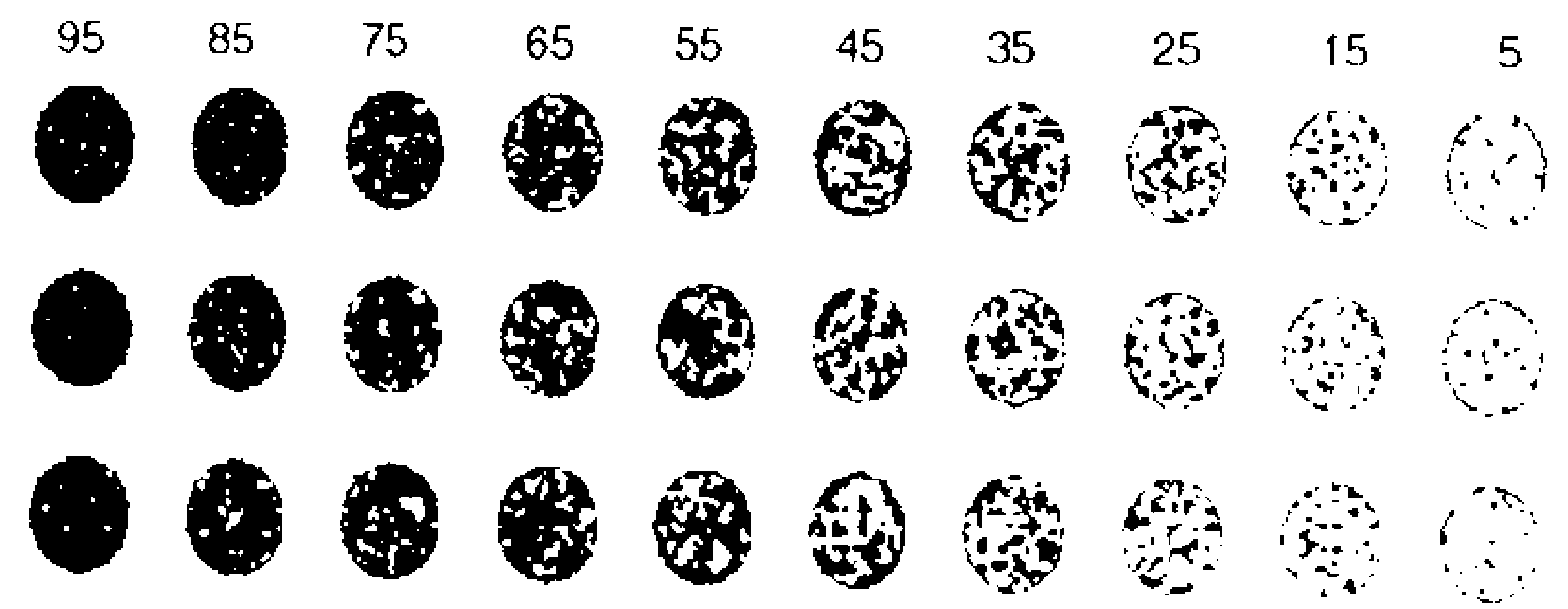
This method is relatively easy to use, but is not precise. Canopy estimates may be somewhat variable, especially between different estimators. Furthermore, estimates tend to be more precise at very high or low canopy cover levels and less precise when canopy cover is nearer to 50%. This method is probably most useful for making preliminary estimates of canopy cover. For example, visual estimates can be used to distinguish between areas with high and low levels of canopy cover when assigning canopy cover strata for a stratified sample. In such cases, the canopy cover class can be estimated using an appropriate rating scale rather than attempting to estimate the actual cover class percentage.
This is an easy, accurate, and relatively rapid method for determining canopy cover, and is equally applicable to natural woodlands and planted urban forests. A dot grid is simply a set of dots, symbols, or intersecting grid lines that is superimposed over an image. Tree canopy cover is estimated by counting the number of dots that that fall on tree crowns compared with the total number of dots in the area sampled. Tree canopy cover can then be calculated from the following formula:
% canopy cover = 100 x (dots falling on tree canopy/total number of dots within sampled area)
Types of dot grids. Regular, uniformly-spaced grids are most commonly used, but the dots (sample points) can also be arranged in a spatially stratified random pattern. If you are using printed photographs, a sheet of transparent material imprinted with dots is laid over the photo. The dots may be easier to resolve if a light box is used under the photo, and magnification may be necessary if tree canopies are small in the photo. Dot grids to be used with photographs can be purchased from forestry equipment suppliers or you can produce your own by printing a grid developed with graphics software onto transparency material (view an example of a uniform dot grid here). If your aerial imagery is in digital format, the dot grid can be superimposed over the photo using graphics software. If the grid is fixed in place (generally by grouping the grid and the underlying image), you can use your graphics program's zoom function to examine the image and dot grid at whatever magnification is necessary to resolve tree canopies clearly. An example of the use of a digital dot grid is shown in the page Comparison of image analysis and dot grids for calculating tree canopy cover.
Sources of error. Dot grid counts are subject to both classification errors and sampling error. If sample size is adequate (see following discussion), random statistical error can be minimized. Sampling bias may be a problem if a regular dot grid is superimposed on a photo with features that repeat in a regular pattern, such as rectangular city blocks. You can use a stratified random dot grid, or make sure that the dot grid is always skew relative to the street grid to minimize this type of sampling bias.
Sample size. How many dots do you need to count? The answer to this question is not simple. Various sampling considerations are discussed and illustrated on the page Determining sample size for dot grid estimates. Although counting high numbers of dots can be tedious, it can be accomplished fairly quickly if the contrast and resolution of the aerial image are good. Sample size may be increased either by using a denser dot grid or by randomly repositioning the grid over the image and recounting. Data from several independent counts of the same area can be aggregated to produce an overall estimate of canopy cover.
This method is analogous to the dot grid method and provides similar levels of precision. In this method, lines are superimposed on the aerial image and the length of each line that overlays tree canopy is compared to the total line length. Canopy cover is then calculated as follows:
% canopy cover = 100 x (length covered by tree canopy / total length of sample)
Lines may be printed on a transparent sheet or can be designated by randomly positioning a clear plastic ruler on the photo. If streets or other features are arranged in parallel lines, sampling bias is best avoided by using a random arrangement of lines rather than parallel lines on the sampling overlay. Accuracy is improved by using more short lines rather than few long lines.
The line intercept and dot grid methods can be also be combined as follows. A line with periodic points (regularly or randomly spaced) is superimposed over the image and the number of points that fall on tree canopy is recorded. Percent canopy is calculated as for the dot grid method, i.e.,
% canopy cover = 100 x (points falling on tree canopy/total number of points along sampled lines)
The line intercept or hybrid point-line method are especially useful for measuring tree canopy along streets (see Measurement of Canopy Cover at the Edge of Pavement [CCEP]).
Any image you can view and store on a computer is referred to as a digital image. The word digitize generally refers to the process of converting images to a digital format, but it is also used to describe the conversion of raster-based images to vector-based format. Raster images are collections of pixels, which can be thought of as small squares in a very fine grid. Each pixel is associated with information on color value and intensity for that portion of the grid. Images in vector format are in the form of points, lines, and closed figures called polygons. Points are described by coordinates and the positions, directions, and shapes of lines are described by geometric and mathematical relationships. Although GIS and CAD software work with both raster and vector data to varying degrees, vector data are used for most mapping applications.
There are several ways to convert raster data, such as aerial photographs showing tree canopy, to vector data. Manual digitizing involves the use of a handheld digitizer and digitizing tablet to trace tree outlines and directly produce tree canopy polygons. Alternatively, digital image can be displayed on a computer screen and tracing of the image is done on-screen using the computer mouse. This is referred to as "heads-up" digitizing. Specialized "interactive tracing" software can be used to facilitate the process further. Finally, some software uses image processing and pattern recognition techniques to automatically convert raster to vector data, especially printed material such as maps and plans. Once information such as tree canopy is represented as vector-based polygons, GIS and CAD programs can use these polygons directly to determine their total area, which can be used to calculate percent canopy cover.
Raster image data can also be used to calculate tree canopy cover directly, but some manipulation of the image is typically needed before canopy cover can be calculated. In most types of imagery, including black and white or color images that have been scanned or captured with digital cameras, items of interest such as tree canopy are typically represented as a collection of pixels that vary in color and/or intensity. Image analysis software uses a variety of techniques to convert an image into a series of monochromatic layers, each of which represents a single type of feature. Once all trees are represented as pixels of a unique value that differs from that of all other features, the percent canopy cover can be calculated. It may also be possible to differentiate between different types of tree canopy using image analysis software. The page Comparison of image analysis and dot grids for calculating tree canopy cover shows one way that basic image analysis techniques can be used to produce a raster-based image layer of tree canopy cover.
Digital image analysis techniques have the potential to provide precise estimates of canopy cover, but photointerpretation errors can still result in bias due to misclassification. Sampling errors can also still be important, particularly if analysis is conducted only on representative sample areas instead of the entire management unit. The costs and effort associated with these methods can be relatively high unless the necessary computer hardware, software, and trained personnel are already on hand. Even if the resources to perform these analyses are readily available, it will typically take much more time to assess canopy cover using either raster or vector image analysis techniques than by using dot grid counts. However, digital image analysis can create permanent maps of tree canopy distribution that may be incorporated into a GIS and/or used to show how and where tree canopy distribution changes over time. If data will be used for these other purposes, the additional cost of digitizing tree canopy can probably be justified.